POINTS OF INTEREST
 artigiani e produttori
 panorama
 cultura
 aree di sosta
MADESIMO TO RASDEGLIA AND TORNI
The route begins from the main street in Madesimo heading south along the municipal road which takes you out of the village. Having passed by the dam and reservoir built in the 60’s, go through the tunnel leading to the SS36 from Lake Como to Spluga.
At the end of the tunnel, head downhill for around 150 metres as far as the junction on the right which takes you gently down to Isola (2km), by way of the SP 1. You’ll reach the village of Isola and follow the signs indicating the way to Mottaletta which involves an uphill stretch of around 1 km. From here you can carry on along the road for Rasdeglia (2km) or explore the little nucleus of Mottaletta itself (path C18).
Once in Rasdeglia have a good look at the càrden, ancient architectural gems constructed using trunks of fir, larch or chestnut, overlapping and with angular joints at the extremities. Classic buildings used as dwellings or indeed stables and barns. From the village follow the signs for the “Via Spluga”, a popular cultural-hiking route that connects Italy and Switzerland, and just before reaching the bridge over the Liro torrent there’s a short steep stretch where it’s a case of slinging your bike over your shoulder and footing it! We are at the very bottom of the Cardinello Gorge, a spectacular and profound ravine that has been traversed since ancient times. Having crossed the torrent, head north for a short distance before shifting right to return to Isola on the other slope. On the way down you’ll come across the hamlets of Torni and Cà di Goss.
Arriving in Isola get back on the SP1 as far as the junction which takes you to Pianazzo and at the church there turn left and take the ancient roadway, now closed to traffic, to return to Madesimo. Along the asphalt surface you’ll get the chance to admire the Catino waterfall, with its drop of fully 100 metres fed by waters from the Scalcoggia torrent. The name of the waterfall - “washbowl” - is derived from the shape adopted by the rocks at the base following erosion due to the force of the falling water.
ALTIMETRY
DETAILS
 |
LENGTH | km |
 |
DURATION | h |
 |
difficulty | 3/4 |
 |
AVERAGE GRADIENT | % |
 |
PERIOD | From May to October |
 |
MOBILITY MEANS | mountain bike |
 |
bikeability | % |
 |
TERRAIN | asphalt, pathway |
 |
PANORAMA | 2/4 |
CALCOLA IL PERCORSO
CICLOTURISMO IN VALTELLINA
Percorsi ciclabili in Valchiavenna e a Madesimo
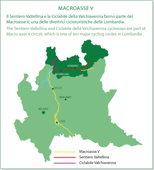
MACROASSE V