POINTS OF INTEREST
 artigiani e produttori
 panorama
 cultura
 aree di sosta
ISOLA TO ALPE FRONDAGLIO
A bike outing which sets out from the parking area at Isola in front of the hydro-electric plant, from where you head up the asphalt road that winds through the heart of the little community. On the way through you’ll note some genuine references to history and in particular perhaps the Locanda Cardinello, which has been providing board, lodging and refreshments to wayfarers since 1722. You might also cast an eye in the direction of the Parish Church dedicated to Santi Giorgio and Martino, with its splendid exhibition of sacred works. Nowadays Isola represents one of the stages of the Via Spluga, the historic hiking trail that connects Switzerland to Italy.
Once at the upper bridge (about 200m above) take a right turn following the signs that will lead you to the village of Motaletta. Just before the habitation the main road switches left and carries on to “Cà Raseri”. From this point on the road assumes more of a consortium character, and noise and disturbance of traffic soon become a distant memory. Pedalling through the tiny hamlet of Canto you’ll spot dwellings known as càrden, typical rustic buildings of the Alpine valleys present throughout Valchiavenna.
At the bridge crossing the Febbraro Torrent swing left onto a dirt road, initially quite gentle in nature but gradually becoming ever steeper. From here you can’t go wrong, simply follow the dirt road taking you to alpe Frondaglio. It’s picture-postcard time here at the foot of the Pian dei Cavalli, recognised as being one of the most beautiful (and popular) spots locally from both a naturalistic and historical point of view. For anyone emboldened by the outing so far, there remains the further possibility of a short detour in Val Febbraro to take in the splendid waterfall.
For the descent, head back to the bridge crossed on the outward leg, and now it’s time to follow the signs marking the “C29” leading to the lush meadows of Isola (a section for the elite bikers to appreciate, with the alternative of following the asphalt road back down). This section forms part of the Via Alpina, a hiking trail which takes in eight sections of the Alpine arc in stages.
ALTIMETRY
DETAILS
 |
LENGTH | km |
 |
DURATION | h |
 |
difficulty | 3/4 |
 |
AVERAGE GRADIENT | % |
 |
PERIOD | From May to October |
 |
MOBILITY MEANS | mountain bike |
 |
bikeability | % |
 |
TERRAIN | asphalt, pathway |
 |
PANORAMA | 3/4 |
CALCOLA IL PERCORSO
CICLOTURISMO IN VALTELLINA
Percorsi ciclabili in Valchiavenna e a Madesimo
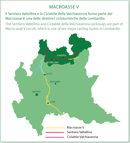
MACROASSE V