POINTS OF INTEREST
 artigiani e produttori
 panorama
 cultura
 aree di sosta
ISOLA TO ALPE BORGHETTO
The itinerary heads off from the populated area of Isola, which forms part of the municipality of Madesimo, as far as the high pasturelands of Borghetto (1.897m) in Val Febbraro, situated on the edge of the grassy terrace. The name Isola derives from the fact that the settlement once stood on land surrounded by marshlands. The valley you will be following along this route brings you to Passo Baldiscio (2.350 m) which marks the border with Val Mesolcina (Switzerland), formerly a territory renowned for its popularity with smugglers.
From Isola, which sits at the intersection of Valle del Liro and Val Febbraro, you climb up the asphalt road that takes in the hamlets of Canto and Ca’ Raseri as far as Stabisotto. You’re at the start of a valley full of fine examples of càrden, rustic buildings noted throughout Valchiavenna, constructed with one side facing upstream, in stone or masonry, called chjä da föç, (house of fire), and another orientated towards the valley in wood which served as both living room and bedroom. This latter section of the building comprised four walls of perfectly-squared, horizontally superimposed beams, hinged at the extremities.
Once you’ve made it to Stabisotto (1.630 m.) carry on along a dirt road with a fairly compacted surface in woodland. When you emerge you’re amongst pastures above 1.800m with lots of twists and turns on ground rather more uneven. This is followed by a long traverse at altitude (above 2000m) that moves from the village of Avert Piani and scrambles its way through meadows on some particularly conspicuous slopes. The road then suddenly shifts southwards dipping down smartly to the mountain dwellings of Borghetto. Time to return to the valley or to Ca’ Raseri where you can continue along the valley to enjoy the Val Febbraro waterfall or pedal on the other valley side to reach the hamlets of Frondaglio or Baituscio, situated at the foot of the Pian dei Cavalli.
For any cyclist who combines photography with his outdoor pursuits the best time to tackle this itinerary is Autumn when the larch foliage is at its most spectacular.
ALTIMETRY
DETAILS
 |
LENGTH | km |
 |
DURATION | h |
 |
difficulty | 3/4 |
 |
AVERAGE GRADIENT | % |
 |
PERIOD | From May to October |
 |
MOBILITY MEANS | mountain bike |
 |
bikeability | % |
 |
TERRAIN | asphalt, pathway |
 |
PANORAMA | 3/4 |
CALCOLA IL PERCORSO
CICLOTURISMO IN VALTELLINA
Percorsi ciclabili in Valchiavenna e a Madesimo
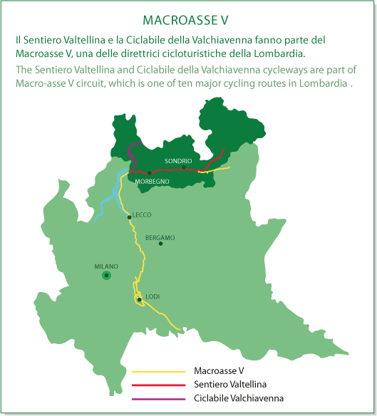
MACROASSE V